

Nineteen Kilometres to Ghepan Lake: Notes From a Trail That Refuses to Behave
There’s a particular kind of trek that doesn’t hold your hand. It shows you a direction, maybe a worn patch of grass where feet have gone before, and then leaves you to figure out the rest. Ghepan Lake Trek is that kind of trek. Nineteen kilometres of gradual climbs, long stretches of boulder-hopping, and a trail that’s marked just enough to make you think you know where you’re going — right until you don’t see the Ghepan Lake.
This isn’t a walk you do for the Instagram grid, though the lake at the end will absolutely end up there. You do it because somewhere past the confusion, past the second-guessing, there’s a glacial lake sitting quietly at over 4,000 metres that most people will never see.
Getting to Sissu
Everything starts in Sissu, a small settlement on the Manali–Leh highway that most travellers barrel past on their way to Ladakh. You can get here by public bus, by hitchhiking (surprisingly reliable on this stretch), or by catching a bus headed toward Keylong that passes through.
Once you’re in Sissu, don’t rush straight to the trailhead. Just across from Sissu Waterfall is a lesser-known one — Ghepan Waterfall — and from there a small connecting road leads toward Labrang Gompa and the Zechum Dolma Monastery. It’s worth the short detour before the real climbing begins.
The Road to the Gompa
From Sissu, it’s about 1.8 kilometres to the Gompa. You have a choice here — hike it, or take a taxi if you’d rather save your legs for what’s ahead. Self-driving works too, up to a point. There’s parking near the Gompa itself, and the road beyond is under construction, though you can still nudge a vehicle a little further before you’ll have to get out and walk, regardless.
Where the Trail Starts Testing You
A couple of kilometres past the Gompa, the actual trailhead appears. The next stretch — about 1.5 km — is where things get interesting. Several trails branch off in different directions, and more than one of them will quietly lead you downhill and away from where you actually want to be.
Keep moving north. That’s really the only rule that matters here. The main trail is there, but you have to want to find it.
This is also where the trail starts playing tricks on you. It’s less about following a visible path and more about having a sense of direction that doesn’t waver when the ground gets ambiguous. We had a guide with us — Shaswat — and there were more than a few moments where his read on which way was actually north mattered more than anything printed on a map.
The Ice Stream, and a Fork That Matters
Roughly halfway in, you hit a stream — impossible to miss, half of it still carrying ice even when the sun is out. This is another point where the trail splits into multiple options.
A local Gaddi we crossed paths with pointed us uphill, and it turned out to be the right call. We crossed the ice stream, took the uphill route, and kept following the trail from there. If there’s one thing this trek teaches you, it’s that the shepherds moving through these valleys know the land in a way no app ever will.
The Boulder Stretch
Somewhere further along, the trail forks again — one branch climbing steeply to the right over a set of boulders that turn out to be far more technical than they look from a distance. We started up that way, realised it wasn’t the move, climbed back down, and picked up the actual trail again lower down.
What follows is a long, unglamorous stretch of boulders — big ones, small ones, no real pattern to them — that makes up close to three-quarters of the entire trek. This is where you slow down, watch your footing, and just keep gaining height. There’s no shortcut through this part. You put your head down and cross it.
The Final Approach
Eventually the ground eases up again — a gradual gradient after all that boulder work feels almost generous. As you descend toward the lake, the trail splits one more time, one path curving off to the left. By this point fatigue has usually set in, so it’s worth paying attention here — a wrong turn this late costs more than it would have earlier.
Ghepan Lake
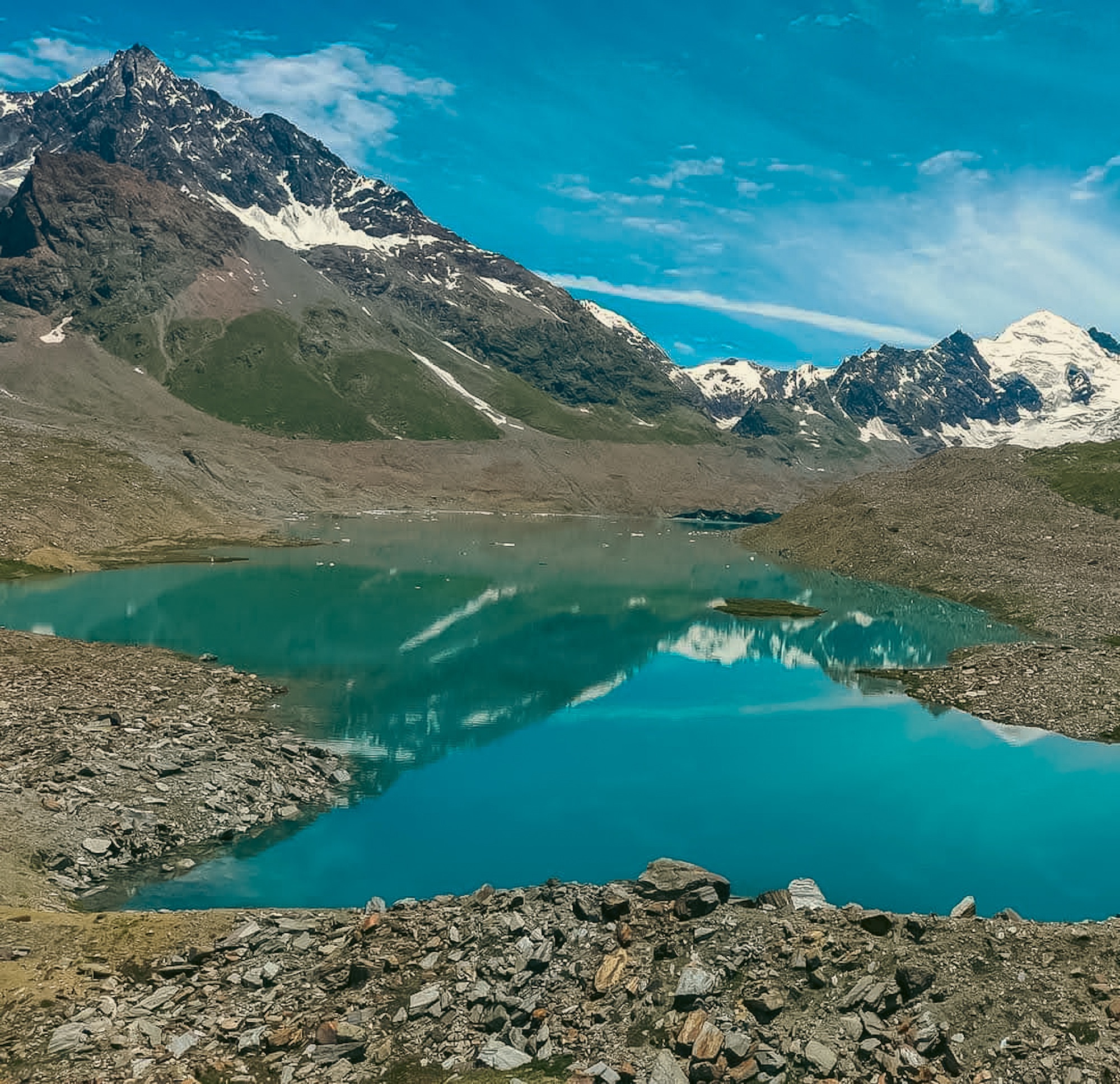
And then, if the sky is behaving, there it is. Ghepan Peak stands over the lake like it’s been waiting the whole way, and on a clear day you can see the glacier that feeds it. The lake sits ringed by mountains to the west, with a river stream quietly working its way out from the basin. It’s turquoise in a way photographs never quite capture — fed by three separate glaciers, which is part of why the colour holds so steady regardless of what the sky is doing.
It’s one of those places that makes the entire boulder field feel less like an obstacle and more like a toll you were always going to have to pay.
How Long It Takes
- Sissu to the lake: around 7 hours
- Lake back to Sissu: around 5 hours downhill
- Total, round trip: roughly 12 hours if you’re doing it in a single push
That’s a long day at altitude, and it demands more than casual fitness. Start early, know your pace, and don’t romanticise the timeline — the mountain doesn’t care how good your itinerary looked on paper.
A Few Things Worth Knowing Before You Go
The trail markers are inconsistent at best, so carry offline maps or GPS as a backup, not a formality. If you cross a Gaddi or shepherd along the way, ask — their read of the terrain beats most signage you’ll find. Trekking poles earn their weight in the boulder stretch. And go in accepting that the view is weather-dependent — Ghepan Peak and its glacier only show themselves on a clear day, so leave some room in your plans for that.
The Lake, and What’s Happening Beneath It
Standing at Ghepan, it’s easy to assume the lake has always looked this way and always will. That blue feels permanent. It isn’t.
Lakes like Ghepan exist because glaciers are melting, and as Himalayan temperatures keep climbing, that melt has been speeding up — which means these lakes aren’t just sitting there, they’re growing. Himachal Pradesh alone has over 300 identified glacial lakes at this point, and a meaningful number of them now fall into high or very-high risk categories, largely because the moraine or ice damming them wasn’t built to hold back this much water for this long. When one of those natural dams gives way, it doesn’t trickle — it lets go all at once, sending a wall of water and debris downstream with almost no warning. That’s what’s known as a Glacial Lake Outburst Flood, or GLOF.
This isn’t hypothetical. Kinnaur district lived through exactly this in 2005, when the Pareechu Lake burst and tore through the region. More recently, similar events across Uttarakhand, Sikkim, and neighbouring Himalayan belts have wiped out hydropower infrastructure, taken down bridges, and permanently reshaped riverbeds. In areas like Kullu, researchers are now projecting a sharp rise in the likelihood of a GLOF event in the coming years, along with a much larger downstream area that would be affected if one occurs.
None of this means you shouldn’t go. It means that when you finally stand at the edge of that impossibly blue water, it’s worth remembering the lake isn’t a fixed postcard. It’s part of a system shifting faster than most of us realise — and being there is a reason to pay attention, not just a reason to take a photo.
RELATED
कुछ और रास्ते जो सफ़र के बाद भी साथ रहे।
Experience · 25 Aug 2026
नॉर्थईस्ट भारत से पहली मुलाक़ात | असम, नागालैंड, मेघालय ट्रैवलॉग
Guide · 25 Aug 2026
सोता हुआ बुद्ध: संदाकफू रिज से कंचनजंगा का वो नज़ारा जो भूला नहीं जाता
Guide · 20 Aug 2026